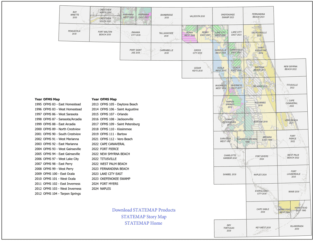
Download over 20 years of STATEMAP research by clicking the open-file map series below or visit our interactive Story Map,
Geologic Mapping in Florida: The STATEMAP Program.
Click the thumbnail above to select and download STATEMAP products by area.
OFMS 83 - East Homestead
Surficial and Bedrock Geology of the Eastern Portion of the U.S.G.S. 1:100,000 Scale Homestead Quadrangle, by R. Green, K. Campbell, and T. Scott, 1995.
OFMS 83 - West Homestead
Surficial and Bedrock Geology of the Western Portion of the U.S.G.S. 1:100,000 Scale Homestead Quadrangle, by R. Green, K. Campbell, and T. Scott, 1996.
OFMS 86 - West Sarasota
Surficial and Bedrock Geology of the Western Portion of the U.S.G.S. 1:100,000 Scale Sarasota Quadrangle, by R. Green, T. Scott, K. Campbell, J. Arthur, and G.H. Means, 1997.
OFMS 87 - Sarasota/Arcadia
Surficial and Bedrock Geology of the Eastern Portion of the U.S.G.S. 1:100,000 Scale Sarasota Quadrangle and the Western Portion of the U.S.G.S. 1:100,000 Scale Arcadia Quadrangle, South-Central Florida, by R. Green, T. Scott, K. Campbell, and G.H. Means, 1998.
OFMS 88 - East Arcadia
Surficial and Bedrock Geology of the Eastern Portion of the U.S.G.S. 1:100,000 Scale Arcadia Quadrangle, South-Central Florida, by R. Green, G.H. Means, T. Scott, J. Arthur, and K. Campbell, 1999.
OFMS 89 - North Crestview
Surficial and Bedrock Geology of the Northern Portion of the U.S.G.S. 1:100,000 Scale Crestview Quadrangle, Northwestern Florida, by G.H. Means, R.C. Green, J.R. Bryan, T.M. Scott, K.M. Campbell, M.M. Gaboardi, and J.D. Robertson, 2000
OFMS 90 - South Crestview
Surficial and Bedrock Geology of the Southern Portion of the U.S.G.S. 1:100,000 Scale Crestview Quadrangle, Northwestern Florida, by R.C. Green, G.H. Means, T.M. Scott, M.M. Gaboardi, W.L. Evans, D.T. Paul, and K.M. Campbell, 2001
OFMS 91 - West Marianna
Surficial and Bedrock Geology of the Western Portion of the U.S.G.S. 1:100,000 Scale Marianna Quadrangle, Northwestern Florida, by R.C. Green, W.L. Evans, J.R. Bryan, D.T. Paul, and M.M. Gaboardi, 2002.
OFMS 92 - East Marianna
Surficial and Bedrock Geology of the Eastern Portion of the U.S.G.S. 1:100,000 Scale Marianna Quadrangle, Northwestern Florida, by R.C. Green, W.L. Evans, J.R. Bryan, and D.T. Paul, 2003.
OFMS 93 - West Gainesville
Geologic Map of the Western Portion of the U.S.G.S. 1:100,000 Scale Gainesville Quadrangle, Northern Florida, by W.L. Evans, R.C. Green, J.R. Bryan, and D. T. Paul, 2004.
OFMS 94 - East Gainesville
Geologic Map of the Eastern Portion of the U.S.G.S. 1:100,000 Scale Gainesville Quadrangle, Northern Florida, by R.C. Green, W.L. Evans III, D.T. Paul, and T.M. Scott, 2005.
OFMS 97 - West Lake City
Geologic Map of the Western Portion of the U.S.G.S. 1:100,000 Scale Lake City Quadrangle, Northern Florida, by R.C. Green, D.T. Paul, W.L. Evans III, T.M. Scott, and S.B. Petrushak, 2006.
OFMS 98 - East Perry
Geologic map of the eastern portion of the U.S.G.S. Perry 30 x 60 minute quadrangle, northern Florida [3 plates], by R.C. Green, D.T. Paul, S.B. Petrushak, C. Kromhout, and T.M. Scott, 2007. Scale: 1:100,000. STATEMAP. Includes Open-File Report 91, Text to accompany geologic map of the eastern portion of the U.S.G.S. Perry 30 x 60 minute quadrangle, northern Florida, by R.C. Green, D.T. Paul, and T.M. Scott, 2007, 32 p.
OFMS 99 - West Perry
Geologic map of the western portion of the U.S.G.S. Perry 30 x 60 minute quadrangle, northern Florida [3 plates], by R.C. Green, D.T. Paul, D.J. Wagner, C. Kromhout, and T. M. Scott, 2008. Scale: 1:100,000. STATEMAP. Includes Open-File Report 92, Text to accompany geologic map of the western portion of the U.S.G.S. Perry 30 x 60 minute quadrangle, northern Florida, by R.C. Green, D.T. Paul, and T.M. Scott, 2008, 35 p.
OFMS 100 - East Ocala
Geologic map of the eastern portion of the U.S.G.S. Ocala 30 x 60 minute quadrangle, north-central Florida [3 plates], by R.C. Green, C.P. Williams, D.T. Paul, C.Kromhout, and T.M. Scott, 2009. Scale: 1:100,000. STATEMAP. Includes Open-File Report 93, Text to accompany geologic map of the eastern portion of the U.S.G.S. Ocala 30 x 60 minute quadrangle, north-central Florida, by R.C. Green, C.P. Williams, D.T. Paul, C. Kromhout, and T.M. Scott, 2009, 28 p.
OFMS 101 - West Ocala
Geologic map of the western portion of the U.S.G.S. Ocala 30 X 60 minute quadrangle, north-central Florida [3 plates], by R.C. Green, C.P. Williams, A.D. Flor, D.T. Paul, C. Kromhout, and T.M. Scott, 2010. Scale: 1:100,000. STATEMAP. Includes Open-File Report 94, Text to accompany geologic map of the western portion of the U.S.G.S. Ocala 30 X 60 minute quadrangle, north-central Florida, by C.P. Williams, R.C. Green, A.D. Flor, D.T. Paul, T.M. Scott, and C. Kromhout, 2010, 29 p.
OFMS 102 - East Inverness
Geologic map of the eastern portion of the U.S.G.S. Inverness 30 x 60 minute quadrangle, central Florida [3 plates], by R.C. Green, C.P. Williams, K.E. Burdette, S.W. Bassett, A.D. Flor and D.T. Paul, 2011. Scale: 1:100,000. STATEMAP. Includes Open-File Report 96, Text to accompany geologic map of the eastern portion of the U.S.G.S. Inverness 30 X 60 minute quadrangle, central Florida, by C.P. Williams, K.E. Burdette, R.C. Green, S.W. Bassett, A.D. Flor, and D.T. Paul, 2011, 40 p.
OFMS 103 - West Inverness
Geologic map of the western portion of the U.S.G.S. Inverness 30 x 60 minute quadrangle, central Florida [3 plates], by C.P. Williams, R.C. Green, S.W. Bassett, L.M. Hannon and A.D. Flor, 2012. Scale 1:100,000. STATEMAP. Includes Open-File Report 97, Text to Accompany geologic map of the western portion of the U.S.G.S. Inverness 30 x 60 minute quadrangle, central Florida, by C.P. Williams and R.C. Green, 2012, 29 p.
OFMS 104 - Tarpon Springs
Geologic map of the U.S.G.S. Tarpon Springs 30 x 60 minute quadrangle, central Florida [3 plates], by R.C. Green, W.L. Evans, C.P. Williams, C. Kromhout, S.W. Bassett, and L.M. Hannon, 2012. Scale: 1:100,000. STATEMAP. Includes Open-File Report 98, Text to accompany geologic map of the U.S.G.S. Tarpon Springs 30 x 60 minute quadrangle, central Florida, by R.C. Green, W.L. Evans III, C.P. Williams, C. Kromhout, and L.M. Hannon, 2012, 40 p.
OFMS 105 - Daytona Beach
Geologic map of the U.S.G.S. Daytona Beach 30 x 60 minute quadrangle, northeast Florida [3 plates], by R.C. Green, W.L. Evans III, S. W. Bassett, and L.M. Hannon, 2013. Scale: 1:100,000. STATEMAP. Includes Open-File Report 101, Text to accompany geologic map of the U.S.G.S. Daytona Beach 30 x 60 minute quadrangle, northeast Florida, by R.C. Green, W. L. Evans III, and S.W. Bassett, 2013, 37 p.
OFMS 106 - Saint Augustine
Geologic map of the U.S.G.S. Saint Augustine 30 x 60 minute quadrangle, northeast Florida [3 plates], by R.C. Green, C.P. Williams, K.M. Campbell, P.W. Bambach, L.M. Hannon, S.W. Bassett, W.L. Evans III, D.T. Paul, and B. Apolinar, 2014. Scale: 1:100,000. STATEMAP. Includes Open- File Report 102, Text to accompany geologic map of the U.S.G.S. Saint Augustine 30 x 60 minute quadrangle, northeast Florida, by R.C. Green, C.P. Williams, K.M. Campbell, P.W. Bambach, L.M. Hannon, S.W. Bassett, W.L. Evans III, D.T. Paul, and B. Apolinar, 2014, 34 p.
OFMS 107 - Orlando
Geologic map of the U.S.G.S. Orlando 30 x 60 minute quadrangle, central Florida [3 plates], by R.C. Green, C.P. Williams, P.W. Bambach, L.M. Hannon, B. Apolinar, K.M. Campbell, and S.B. Dyer, 2015. Scale: 1:100,000. STATEMAP. Includes Open-File Report 104, Text to accompany geologic map of the U.S.G.S. Orlando 30 x 60 minute quadrangle, central Florida, by R.C. Green, C.P. Williams, P.W. Bambach, L.M. Hannon, B. Apolinar, K.M. Campbell, and S.B. Dyer, 2015, 37 p.
OFMS 108 - Jacksonville
Geologic map of the U.S.G.S. Jacksonville 30 x 60 minute quadrangle, northeast Florida [3 plates], by R.C. Green, C.P. Williams, P.W. Bambach, B. Apolinar, L. M. Hannon, and K.M. White, 2016. Scale 1:100,000. STATEMAP. Includes Open-File Report 105, Text to accompany geologic map of the U.S.G.S. Jacksonville 30 x 60 minute quadrangle, northeast Florida, by R.C. Green, C.P. Williams, P.W. Bambach, B. Apolinar, L.M. Hannon, and K.M. White, 2016, 31 p.
OFMS 109 - Saint Petersburg
Geologic map of the U.S.G.S. Saint Petersburg 30 x 60 minute quadrangle, west central Florida [3 plates], by R.C. Green, B. Apolinar, C.P. Williams, K.M. White, S.W. Bassett, and L.F. Nason, 2017. Scale 1:100,000. STATEMAP. Includes Open-File Report 106, Text to accompany geologic map of the U.S.G.S. Saint Petersburg 30 x 60 minute quadrangle, west central Florida, by R.C. Green, B. Apolinar, C.P. Williams, K.M. White, S.W. Bassett, and L.F. Nason, 2017, 45 p.
OFMS 110 - Kissimmee
Geologic map of the U.S.G.S. Kissimmee 30 x 60 minute quadrangle, central Florida [3 plates], by R.C. Green, C.P. Williams, C.A. Albritton, K.M. White, A.G. Lamarche, S.W. Bassett, and L.F. Nason, 2018. Scale 1:100,000. STATEMAP. Includes Open-File Report 107, Text to accompany geologic map of the U.S.G.S. Kissimmee 30 x 60 minute quadrangle, central Florida, by R.C. Green, C.P. Williams, C.A. Albritton, K.M. White, A.G. Lamarche, and S.W. Bassett, 2018, 46 p.
OFMS 111 - Bartow
Geologic map of the U.S.G.S. Bartow 30 x 60 minute quadrangle, central Florida [3 plates], by R.C. Green, C.P. Williams, A.G. Lamarche, C.L. Hebets, C.A. Albritton, and G.S. Evans, 2019. Scale 1:100,000. STATEMAP. Includes Open-File Report 108, Text to accompany geologic map of the U.S.G.S. Bartow 30 x 60 minute quadrangle, central Florida, by R.C. Green, C.P. Williams, A.G. Lamarche, C.L. Hebets, C.A. Albritton, and G.S. Evans, 2019, 41 p.
OFMS 112 - Vero Beach
Geologic map of the U.S.G.S. Vero Beach 30 x 60 minute quadrangle, central Florida [3 plates], by R.C. Green, A.G. Lamarche, C.P. Williams, C.L. Hebets, G.S. Evans, and C.A. Albritton, 2021. Scale 1:100,000. STATEMAP. Includes Open-File Report 109, Text to accompany geologic map of the U.S.G.S. Vero Beach 30 x 60 minute quadrangle, central Florida, by R.C. Green, A.G. Lamarche, C.P. Williams, C.L. Hebets, G.S. Evans, and C.A. Albritton, 2021, 33 p.
OFMS 113 - Fort Pierce
Geologic map of the U.S.G.S. Fort Pierce 30 x 60 minute quadrangle, south Florida [3 plates], by R.C. Green, C.P. Williams, C.L. Hebets, J.W. Greene, N.P. Hall, G.S. Evans, and B.M. Duffey, 2022. Scale 1:100,000. STATEMAP. Includes Open-File Report 110, Text to accompany geologic map of the U.S.G.S. Fort Pierce 30 x 60 minute quadrangle, south Florida, by R.C. Green, C.P. Williams, C.L. Hebets, J.W. Greene, N.P. Hall, G.S. Evans, and B.M. Duffey, 2022, 33 p.
OFMS 114 - West Palm Beach
Geologic map of the U.S.G.S. West Palm Beach 30 x 60 minute quadrangle, south Florida [2 plates], by R.C. Green, J.W. Greene, N.P. Hall, C.L. Hebets, G.S. Evans, and C.P. Williams, 2023. Scale 1:100,000. STATEMAP. Includes Open-File Report 111, Text to accompany geologic map of the U.S.G.S. West Palm Beach 30 x 60 minute quadrangle, south Florida, by R.C. Green, J.W. Greene, N.P. Hall, C.L. Hebets, G.S. Evans, and C.P. Williams, 2023, 27 p.
OFMS 115 - Cape Canaveral
Geologic map of the U.S.G.S. Cape Canaveral 30 x 60 minute quadrangle, central Florida [2 plates], by R.C. Green, C.P. Williams, J.W. Greene, C.L. Hebets, G.S. Evans, M.M. Ladle, N.P. Hall, and B.M. Duffey, 2023. Scale 1:100,000. STATEMAP. Includes Open-File Report 112, Text to accompany geologic map of the U.S.G.S. Cape Canaveral 30 x 60 minute quadrangle, central Florida, by J.W. Greene, C.P. Williams, R.C. Green, C.L. Hebets, G.S. Evans, M.M. Ladle, N.P. Hall, and B.M. Duffey, 2023, 28 p.


