
Big Bend Seagrasses Aquatic Preserve
- Home
- Divisions
- Office of Resilience and Coastal Protection
- Aquatic Preserve Program
- Big Bend Seagrasses Aquatic Preserve
Aquatic-Preserve Quick links
- Alligator Harbor Aquatic Preserve
- Apalachicola Bay Aquatic Preserve
- Banana River Aquatic Preserve
- Big Bend Seagrasses Aquatic Preserve
- Biscayne Bay Aquatic Preserves
- Boca Ciega Bay Aquatic Preserve
- Cape Haze Aquatic Preserve
- Cape Romano-Ten Thousand Islands Aquatic Preserve
- Cockroach Bay Aquatic Preserve
- Coupon Bight Aquatic Preserve
- Estero Bay Aquatic Preserve
- Fort Pickens Aquatic Preserve
- Gasparilla Sound-Charlotte Harbor Aquatic Preserve
- Guana River Marsh Aquatic Preserve
- Indian River-Malabar to Vero Beach Aquatic Preserve
- Indian River-Vero Beach to Fort Pierce Aquatic Preserve
- Jensen Beach to Jupiter Inlet Aquatic Preserve
- Kristin Jacobs Coral Aquatic Preserve
- Lake Jackson Aquatic Preserve
- Lemon Bay Aquatic Preserve
- Lignumvitae Key Aquatic Preserve
- Loxahatchee River-Lake Worth Creek Aquatic Preserve
- Matlacha Pass Aquatic Preserve
- Mosquito Lagoon Aquatic Preserve
- Nassau River-St. Johns River Marshes and Fort Clinch Aquatic Preserves
- Nature Coast Aquatic Preserve
- North Fork, St. Lucie Aquatic Preserve
- Oklawaha River Aquatic Preserve
- Pellicer Creek Aquatic Preserve
- Pine Island Sound Aquatic Preserve
- Pinellas County Aquatic Preserves
- Rainbow Springs Aquatic Preserve
- Rocky Bayou Aquatic Preserve
- Rookery Bay Aquatic Preserve
- St. Andrews Aquatic Preserve
- St. Joseph Bay Aquatic Preserve
- St. Martins Marsh Aquatic Preserve
- Terra Ceia Aquatic Preserve
- Tomoka Marsh Aquatic Preserve
- Wekiva River Aquatic Preserve
- Yellow River Marsh Aquatic Preserve
- All Aquatic-Preserve content
The Big Bend Seagrasses Aquatic Preserve was established in 1985.
- Spanning more than 984,000 acres and over 150 miles of coastline, the Big Bend Seagrasses Aquatic Preserve is the largest aquatic preserve and one of the most pristine places in Florida.
- The preserve provides habitat to a wide variety of sea and shore birds due to the diverse selection of habitats like seagrass meadows, oyster reefs, sandy keys, and salt marshes.
- It supports a very important commercial shellfish industry including Cedar Key clams, oysters, pink shrimp and blue crab.
- The preserve supports a popular recreational scallop season during the summer months.
- The Suwannee River region supports essential fish habitat and the most viable population of the threatened Gulf sturgeon.
Resource Management
Big Bend Seagrasses Aquatic Preserve collects valuable water quality data through bimonthly nutrient sampling along the coast and through continuous water quality monitoring. Grab samples are collected at fixed sites within Big Bend Seagrasses Aquatic Preserve for DEP’s Division of Environmental Assessment and Restoration.
The division analyzes the grab samples for chlorophyll, nitrites and nitrates, total Kjeldahl nitrogen (TKN), total phosphorus (TP), and turbidity. Additionally, a continuous water quality monitoring station is located at the mouth of the Steinhatchee River to collect data in 15-minute intervals. YSI EXO multi-parameter datasondes are deployed at this site to collect water temperature, specific conductivity, salinity, dissolved oxygen percent and concentration, water depth, pH, turbidity and chlorophyll. Continuous water quality data is publicly-available on the Aquatic Preserve Data Portal.
These continuous, long-term datasets are valuable in collecting baseline data and monitoring trends over time. With the continuous water quality monitoring station and the bimonthly nutrient grab samples, the water quality of the Big Bend can be closely monitored, and the data can be used by resource managers, planners, permitting agencies, educators, scientists, and the general public to address specific coastal management needs and promote conservation of estuarine habitats.
In addition to water quality monitoring, staff of Big Bend Seagrasses Aquatic Preserve also monitor seagrass and macroalgae at 100 fixed locations annually. Seagrass health and community structure can be analyzed to note any significant changes or trends. Seagrass data is publicly-available on the SEACAR Data Discovery Portal. Seagrass in the Big Bend is negatively impacted by propeller scarring where depths are shallow and boat traffic is high. In order to protect the seagrass, partnerships were established with local agencies and communities.
In 2019, Big Bend Seagrasses Aquatic Preserve was awarded an EPA cooperative agreement to restore seagrass damaged by marine debris. With the help from Florida Fish and Wildlife Conservation Commission (FWC), U.S. Geological Survey, Lower Suwannee National Wildlife Refuge, UF/IFAS Nature Coast Biological Station, Florida Public Archaeology Network and residents of Steinhatchee, over 600 derelict crab traps and other marine debris have been removed from Deadman Bay of Steinhatchee.
Marine debris lays on seagrass for long periods of time, shades it out, and either stunts its growth or kills it. After the marine debris is removed, the surrounding seagrass grows and fills in the bare footprint left behind. Additionally, FWC’s Fish and Wildlife Research Institute performs annual seagrass surveys and developed the Seagrass Integrated Mapping and Monitoring program and report to share seagrass data, stressors, trends, and a report card of each geographical region of seagrass along Florida’s coastline. Florida Sea Grant designed the “Scars Hurt: Be Seagrass Safe” campaign to educate boaters of safe boating practices in shallow seagrass areas. Signs are posted at local boat ramps, and aquatic preserve staff actively promote the Scars Hurt campaign at education and outreach events.
Outreach within the community is an effective way to educate people on the importance of seagrass habitats and how they can help protect this critical resource from physical damage.
United States
As Florida's largest aquatic preserve, and because of the sparse development along its shores, Big Bend Seagrasses Aquatic Preserve has a wealth of recreational opportunities, including swimming, wildlife viewing, boating, canoeing, kayaking, scalloping and fishing. There are several state parks, national wildlife refuges and two paddling trails.
State Parks and National Wildlife Refuges
The aquatic preserve contains submerged Archaic and Paleoindian sites. There are Deptford sites and some Swift Creek sites in the north and Weeden Island sites in the south.
Big Bend Seagrasses Aquatic Preserve is composed primarily of seagrass beds and salt marsh. Other common benthic communities in the aquatic preserve include mollusk reefs, algal beds and sponge beds. The rivers of the aquatic preserve can be either spring-run streams or blackwater streams. Blackwater streams and rivers originate in swampy areas, which is stained dark brown by organic acids.
Seagrass Beds
Image


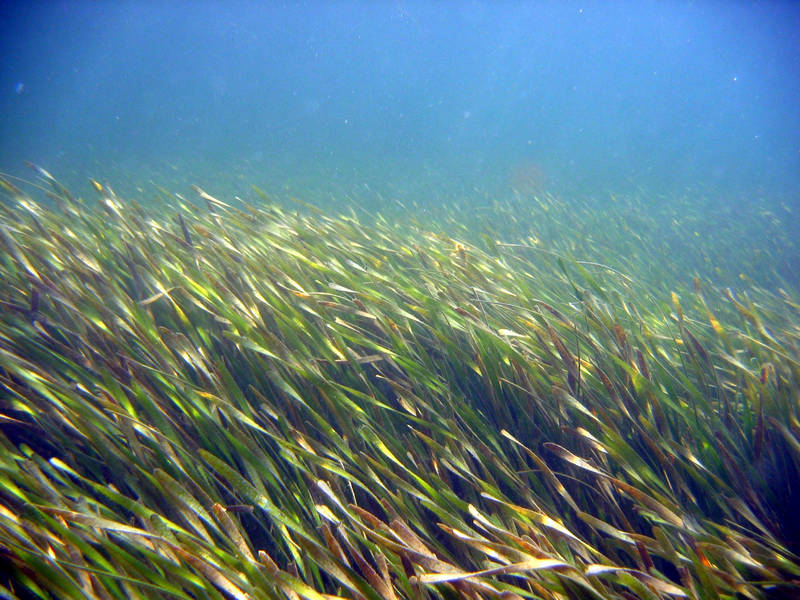
Marine and estuarine seagrass beds are floral-based natural communities typically characterized as expansive stands of vascular plants. This community occurs in subtidal (rarely intertidal) zones in clear, coastal waters where wave energy is moderate. Seagrasses are flowering plants that require sunlight for photosynthesis and have true roots for anchoring down into the sediment. Turtle grass (Thalassia testudinum), manatee grass (Syringodium filiforme), shoal grass (Halodule wrightii), star grass (Halophila engelmannii), widgeon grass (Ruppia maritima), and paddle grass (Halophila decipiens) can be found in Big Bend Seagrasses Aquatic Preserve.
Attached to the seagrass leaf blades are numerous species of epiphytic algae and invertebrates. Together, seagrasses and their epiphytes serve as important food sources for manatees, marine turtles, and many fishes, including spotted sea trout, sheepshead and red drum.
The dense seagrasses also serve as shelter or nursery grounds for many invertebrates and fishes, including marine snails , clams, bay scallops (Argopecten irradians), polychaete worms, pink shrimp, blue crab, sea stars, sea urchins, tarpon, seahorses and striped mullet.
Like mangroves, seagrass act as a storage sink for blue carbon to reduce the amount of greenhouse gases in the atmosphere. Seagrass beds are extremely vulnerable to human impacts.
Algal Beds
Marine and estuarine algal beds are floral-based natural communities with large populations of attached macro or microalgae. This community may occur in subtidal, intertidal and supratidal zones on soft and hard bottom substrates. Vascular plants (e.g., seagrasses) may occur in algal beds associated with soft bottoms.
Sponge Beds
Marine and estuarine sponge beds are soft faunal-based natural communities characterized as dense populations of sponges. Other sessile animals typically occurring in association with these sponges are stony corals, sea anemones, mollusks, tube worms, isopods, amphipods, burrowing shrimp, crabs, sand dollars and fishes. Sessile and drift algae can also be found scattered throughout sponge beds.
Sponge beds require hard bottom (consolidated) substrate (i.e., coquina, limerock, relic reefs) on which to anchor. Hard bottom substrate occurs sparsely throughout Florida in marine and estuarine areas; however, sponges prefer the warmer waters of the southern portion of the state, significantly limiting the distribution.
Salt Marsh
Salt marshes are one of the most biologically productive natural communities in the world due to the tidal fluctuations that cycle nutrients and allow marine and estuarine fauna to access the marsh. Salt marshes are also extremely important because of their storm buffering capacity and their pollutant filtering actions. The dense roots and stems hold the soils together, reducing the impact of storm wave surge. The plants, animals and soils filter, absorb and neutralize many pollutants before they can reach adjacent marine and estuarine communities.
Mollusk Reefs
Marine and estuarine mollusk reefs are faunal-based, natural communities typically characterized as expansive concentrations of sessile mollusks occurring in intertidal and subtidal zones.
Shell Mound
Shell mound is generally characterized as an elevated mound of mollusk shells and Indigenous peoples’ refuse on which a hardwood, closed-canopy forest develops.
Interested in subscribing to DEP newsletters or receiving DEP updates through email?
Sign UpAbout DEP
The Florida Department of Environmental Protection is the state’s lead agency for environmental management and stewardship – protecting our air, water and land. The vision of the Florida Department of Environmental Protection is to create strong community partnerships, safeguard Florida’s natural resources and enhance its ecosystems.
Learn MoreContact
3900 Commonwealth BoulevardTallahassee, Florida 32399-3000 Public.Services@FloridaDEP.gov 850-245-2118
